The exhaustion you feel on a road trip isn’t from the miles you drive, but from a rigid plan that suffocates the very freedom you’re seeking.
- The secret to a liberating journey is designing a flexible framework, not a minute-by-minute itinerary.
- This involves limiting daily driving to a strict maximum and using anchor points (« tent-poles ») to guide your trip, leaving the space between them open for spontaneity.
Recommendation: Abandon the quest for a « perfect » route. Instead, adopt the mindset of a trip designer, creating a resilient structure that thrives on the unexpected.
The dream is universal: open road, endless sky, and the promise of discovery around every bend. Yet, for many, the reality of a multi-week road trip dissolves into a blur of long-haul driving, logistical stress, and the creeping feeling of exhaustion. We meticulously plan routes, book every hotel, and create detailed itineraries, believing that control is the antidote to chaos. We try to « see it all, » and in the process, experience very little.
Common advice tells you to use advanced planning apps, create detailed budgets, and stick to your schedule. But what if this hyper-planning is the very source of the problem? What if the key to a freeing road trip isn’t a more detailed map, but a better compass? The answer lies not in stricter planning, but in smarter design. It’s about creating a ‘road trip flow’—a state where the journey feels effortless, balancing movement with immersion, and structure with spontaneity.
This guide moves beyond conventional advice. It won’t give you a rigid checklist, but a new philosophy for trip design. We’ll explore why long driving days are a recipe for failure, how to build a flexible ‘tent-pole’ plan that encourages discovery, and how to use digital tools to avoid common pitfalls. By shifting from a planner to a designer, you’ll craft a journey that is not only manageable but truly liberating.
To help you navigate this new approach, this article is structured to build your skills as a trip designer, from foundational principles to advanced route-crafting techniques. Let’s explore how to put the freedom back into your road trip.
Summary: Designing a Road Trip That Balances Freedom and Structure
- Why Do Road Trips Fail When You Drive More Than 4 Hours Per Day?
- Compact Car or SUV: Which Vehicle Type Suits European Road Trips Best?
- Fixed Route or Flexible Direction: Which Road Trip Style Reduces Stress?
- The License Violation That Costs Road Trippers £500+ in Fines
- When Should You Drive Scotland’s North Coast 500 for Best Conditions?
- The Distance Calculation Mistake That Ruins Unique Routes for 65% of Planners
- The Driving Assumption That Puts Nervous Drivers on Corsica’s Hairpin Mountain Roads
- How to Create Unique Routes Across Europe That Skip 90% of Tourists’ Stops?
Why Do Road Trips Fail When You Drive More Than 4 Hours Per Day?
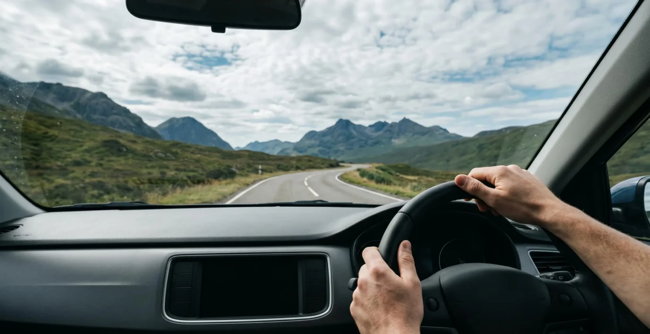
The most fundamental error in road trip design is treating it like a race. The romantic notion of « covering ground » often leads to 6, 8, or even 10-hour driving days. This strategy doesn’t just make you tired; it actively destroys the purpose of the trip. Travel expert Samantha Brown captures the essence of this principle perfectly: « As a rule of thumb, I like to limit driving on a road trip to 2-3 hours a day, no more than 4 hours. I find that any longer, I’m not going to have a lot of time to do anything but drive. » This isn’t just a preference; it’s a strategic limit to preserve energy and create time for the spontaneous stops that define a great journey.
The danger of over-driving goes beyond missed opportunities. It’s a significant safety risk. The mental and physical toll of prolonged driving, known as driver fatigue, has measurable consequences. In fact, being awake for more than 20 hours results in impairment equal to a blood alcohol concentration of 0.08%, the legal limit in most places. When you push past the 4-hour mark, you’re not just tired; you’re becoming a less capable driver. Decision-making slows, reaction times suffer, and the « destination fixation » can lead you to ignore warning signs. A road trip is a marathon, not a sprint, and respecting your cognitive limits is the first step in designing a successful and safe journey.
Compact Car or SUV: Which Vehicle Type Suits European Road Trips Best?
Your vehicle is not just transport; it’s your key to unlocking—or locking yourself out of—the best parts of a region. For European road trips, the « bigger is better » mindset is a trap. While an SUV might seem ideal for comfort and luggage, it often becomes a liability. An analysis of vehicle choices highlights that compact cars grant far better access to the narrow medieval streets, hidden villages, and tiny parking spots that are the soul of European exploration. They enable the spontaneous detours that lead to the most memorable discoveries, turning potential stress into delightful adventure.
The following table breaks down the practical trade-offs. The choice becomes clear when you consider that the primary challenges in Europe are not long, straight highways, but navigating historic centers and finding parking. A smaller vehicle’s superior fuel economy and lower rental cost are also significant factors, freeing up your budget for experiences rather than expenses. An SUV only makes sense if your trip is primarily focused on remote mountain regions or if you’re traveling with a large family and significant luggage, but even then, you must be prepared to leave it parked outside of most historic towns and cities.
| Factor | Compact Car | SUV |
|---|---|---|
| Maneuverability in Cities | Excellent – fits narrow medieval streets | Challenging – difficult in historic centers |
| Parking Access | Easy – fits small spots | Limited – requires larger spaces |
| Fuel Economy | Excellent – 40-50 mpg typical | Lower – 20-30 mpg typical |
| Passenger Comfort (Long Drives) | Good for 2-4 people | Superior for 5+ passengers |
| Luggage Capacity | Limited – 2-3 bags | Generous – 5+ bags |
| Daily Rental Cost | €25-50 | €60-120 |
| Best Use Case | City exploration + flexibility | Long motorway transit + families |
Ultimately, choosing a compact car is a strategic decision that aligns with the philosophy of a flexible, discovery-oriented road trip. It prioritizes agility and access over sheer size, ensuring your vehicle is an enabler of freedom, not a source of frustration.
Fixed Route or Flexible Direction: Which Road Trip Style Reduces Stress?
The greatest source of road trip anxiety stems from a false dichotomy: either plan everything to the minute or plan nothing and risk chaos. The most liberating and stress-free approach lies in the middle. Instead of a rigid, fixed route, a successful trip is built on a flexible framework. This is the essence of « Tent-Pole Planning, » a method that balances the need for structure with the desire for spontaneity. It involves identifying and booking only your key « tent-pole » destinations—perhaps 3 or 4 major stops spaced several days apart—and leaving the routes and days between them completely open to discovery.
This method transforms the journey. The days between your tent-poles are no longer about « getting from A to B » as quickly as possible. Instead, they become a canvas for adventure. You have the freedom to follow a sign to a quaint village, spend an extra hour at a scenic viewpoint, or take a nap by a lake without the nagging feeling that you’re « falling behind schedule. » This approach drastically reduces decision fatigue because the big decisions are already made, while the small, joyful decisions are enabled. It provides the security of knowing where you’ll sleep in a few days, combined with the absolute freedom to explore how you get there.
Your Action Plan: Implementing the Tent-Pole Method
- Identify your key destinations: Select 3-4 must-visit locations spaced 2-3 days apart across your trip duration.
- Book only these anchor accommodations in advance: Secure lodging at each tent-pole location but nothing in between.
- Leave routes between poles completely flexible: Don’t pre-plan roads, timing, or activities for the connecting days.
- Allow spontaneous discoveries: Use the freedom between poles to explore unexpected stops without schedule pressure.
- Build in rest days: Schedule at least one zero-driving day at each tent-pole location to recover and explore locally.
The License Violation That Costs Road Trippers £500+ in Fines
Nothing shatters the feeling of freedom faster than an unexpected, exorbitant fine. One of the most common and costly mistakes for international road trippers in Europe is related to a single document: the International Driving Permit (IDP). While your home country’s license is valid in many places, several popular destinations legally require an IDP alongside it. For non-EU license holders, driving without the required IDP in countries like Italy, Austria, or Spain can result in on-the-spot fines ranging from €100 to several hundred euros. The penalties escalate dramatically if you’re involved in an accident, potentially voiding your rental insurance and leaving you liable for thousands.
Beyond the IDP, a web of local regulations, from low-emission zone (LEZ) stickers in major cities to motorway vignettes, can catch unwary travelers. A missed LEZ payment in London or Paris can lead to fines approaching £1000. This isn’t about memorizing every law; it’s about having a simple, pre-departure protocol to ensure you have the core documents covered. Spending 15 minutes on this checklist before you leave can save you hundreds of pounds and immense stress on the road.
Your Checklist: The 15-Minute Peace of Mind Protocol
- Document 1: International Driving Permit (IDP): Required in 13 European countries including Italy, Spain, Austria, Greece; obtain before leaving home.
- Document 2: Valid passport or national ID card: Essential for all border crossings and rental car pickup.
- Document 3: Vehicle registration document (V5C for UK cars): Must match driver details if using your own vehicle.
- Document 4: Digital or physical vignettes: Pre-purchase for Austria, Switzerland, Czech Republic, and others to avoid fines from €180-€800.
- Document 5: Low Emission Zone (LEZ) compliance: Check requirements for cities like London, Paris, or Milan; failure to register can result in fines up to £1000.
When Should You Drive Scotland’s North Coast 500 for Best Conditions?
Applying trip design principles to a specific route like Scotland’s iconic North Coast 500 reveals that « best » is entirely subjective. The ideal time to go depends on your personal definition of a perfect trip. July and August offer warm weather and a buzzing social scene, but they also bring peak traffic, peak prices, and the infamous Scottish midge. Indeed, Highland travel guides confirm that midges are most active from June to September, making outdoor activities challenging for those unprepared.
A more nuanced approach involves matching the season to your traveler profile. Are you a photographer seeking dramatic light and empty roads, or a social traveler looking for lively pubs? The « best » time for one is the « worst » time for another. Using a framework that considers your priorities allows you to design the experience you truly want, rather than following the crowds into a trip that doesn’t suit you.
| Traveler Profile | Optimal Months | Key Benefits | Considerations |
|---|---|---|---|
| Photographers | April & October | Dramatic light, fewer cars, vivid autumn colors or spring blooms, uncrowded viewpoints | Shorter daylight hours in October, weather unpredictable |
| Hikers & Campers | May & June | Longest days (up to 18 hours daylight), pre-midge season, trails accessible, wild camping comfortable | Late May sees midge arrival, book accommodations in advance |
| Social Travelers | July & August | Bustling pubs, festivals, warmest weather (14-20°C), all attractions open | Peak traffic, highest prices, peak midge season, must book months ahead |
| Budget Travelers | April & September | Lower accommodation prices, fewer crowds, shoulder season rates, mild weather | Some seasonal businesses still closed in April, shorter days in September |
This approach demonstrates that timing is a powerful design tool. By understanding the trade-offs of each season—light, crowds, cost, and even insects—you can make a strategic choice that aligns perfectly with your goals, ensuring your NC500 journey is memorable for all the right reasons.
The Distance Calculation Mistake That Ruins Unique Routes for 65% of Planners
One of the most common ways road trips become exhausting is by trusting GPS time estimates blindly. On scenic, rural, and unique routes, Google Maps is a liar. Its algorithms are optimized for efficient travel on major arteries, not for the reality of winding B-roads, single-track lanes, or tourist traffic. A real-world analysis of popular European scenic routes shows that while posted speed limits might be 60 mph, the actual effective speed often averages just 25-30 mph. This discrepancy means that a journey estimated at 2 hours can easily take 3.5 hours, destroying your schedule and forcing you to rush or skip planned stops.
The solution is not to discard GPS, but to augment it with a dose of reality. Experienced trip designers use a « Time Multiplier » formula, a simple but powerful heuristic to create a more accurate timeline. By applying a multiplier based on the type of road, you transform an optimistic guess into a realistic plan. This gives you a truer picture of your driving day, allowing you to build a schedule that accommodates photo stops, slow-moving tractors, and the simple joy of driving at a relaxed pace. It’s a core tool for maintaining the « road trip flow » and preventing the frustration of constantly being behind schedule.
Your Action Plan: The Time Multiplier Formula for Accurate Route Planning
- A-roads (Major Routes): Multiply Google Maps estimated time by 1.2 to account for tourist traffic and photo stops.
- B-roads (Secondary Routes): Multiply Google Maps time by 1.5 to factor in narrower roads and agricultural vehicles.
- Single-track lanes (Rural/Mountain Roads): Multiply Google Maps time by 1.8-2.0 to allow for passing places and oncoming traffic.
- Urban historic centers: Add 30-45 minutes per city for one-way systems, pedestrian zones, and parking.
- Mountain passes: Add 15-20 minutes per significant elevation change for weather checks and cautious driving.
The Driving Assumption That Puts Nervous Drivers on Corsica’s Hairpin Mountain Roads
The most terrifying moments on a road trip often happen because of a single, flawed assumption: that a line on a map represents a viable road. Many travelers, especially nervous drivers, have found themselves in deeply stressful situations—on narrow, crumbling cliff-edge roads in Corsica or single-track lanes in the Scottish Highlands—because their GPS suggested it as the « fastest » or « most direct » route. The map doesn’t show road width, surface quality, gradient, or the sheer drop to the sea just inches from your tires. Relying solely on a 2D map view is a gamble with your comfort and safety.
To avoid this, trip designers employ a « Digital Reconnaissance » protocol before committing to any questionable route. This isn’t about over-planning; it’s a quick, targeted check to verify that a road matches your vehicle’s capabilities and your personal comfort level. By using free tools like Google’s Satellite, Terrain, and Street View layers, you can virtually « pre-drive » a route in minutes. This simple act of verification can be the difference between a breathtaking scenic drive and a white-knuckle ordeal, ensuring your adventure remains exhilarating for the right reasons.
Your Action Plan: Digital Route Reconnaissance Protocol
- Step 1: Open Google Maps and switch to Satellite View: Examine the actual road width and surface conditions.
- Step 2: Activate the Terrain Layer: Identify elevation changes, mountain passes, and gradient severity.
- Step 3: Use Street View for critical sections: Virtually drive challenging segments to check for hairpin turns and cliff edges.
- Step 4: Cross-reference with local road classifications: Verify if the route uses major roads (A, N) versus minor rural roads (D-roads).
- Step 5: Check local road authority websites: Confirm current closures, construction, or weather restrictions before departure.
Key takeaways
- The primary cause of road trip exhaustion is a rigid schedule and driving more than four hours a day.
- Design for flexibility using « Tent-Pole Planning »: fix a few key destinations and leave the space between them open for discovery.
- Embrace « smarter » planning tools like the Time Multiplier and Digital Reconnaissance to create realistic timelines and avoid stressful road surprises.
How to Create Unique Routes Across Europe That Skip 90% of Tourists’ Stops?
The ultimate goal of a well-designed road trip is to create a journey that is uniquely yours, far from the crowded tourist circuits. The secret to achieving this is not to look for « hidden gems » in a guidebook—by the time they’re in print, they’re no longer hidden. Instead, it’s about changing your discovery process entirely. As highlighted in an analysis of alternative discovery methods, savvy travelers are using specialized, non-tourism platforms like the Komoot hiking app or specific Instagram hashtags to unearth locations invisible to the mainstream. This approach naturally generates routes that bypass the usual stops in favor of authentic local experiences.
The most powerful technique for crafting these routes is « Thematic Layering. » Instead of connecting a series of famous landmarks, you design your route around a niche personal interest or a combination of themes. This method forces you to look at the map differently, revealing a web of connections that others miss. By layering multiple micro-themes—like « local cheese producers + brutalist architecture + wild swimming spots »—you create a path that is entirely personal and impossible to replicate from a standard travel guide. This is the pinnacle of road trip design: transforming a simple trip into a narrative journey that reflects your own curiosity.
Your Action Plan: The Thematic Layering Route Planning Method
- Strategy 1: Choose a niche personal theme: Plan a route around a specific interest like regional distilleries, literary locations, or geological formations.
- Strategy 2: Use non-tourism discovery tools: Search with Komoot for hiking routes, or Instagram hashtags like #wildswimmingfrance for hidden locations.
- Strategy 3: Target ‘in-between places’: Book overnight stops in smaller towns between major tourist hotspots for authentic experiences.
- Strategy 4: Reverse the tourist flow: Drive popular routes in the opposite direction or in the off-season.
- Strategy 5: Layer multiple micro-themes: Combine interests to create an entirely unique path avoiding standard circuits.
By embracing these principles, you shift from being a passive consumer of pre-packaged trips to an active creator of your own adventure. The road becomes more than just a means to an end; it becomes the story itself. To start designing your own liberating journey, the next logical step is to apply this framework to your dream destination.