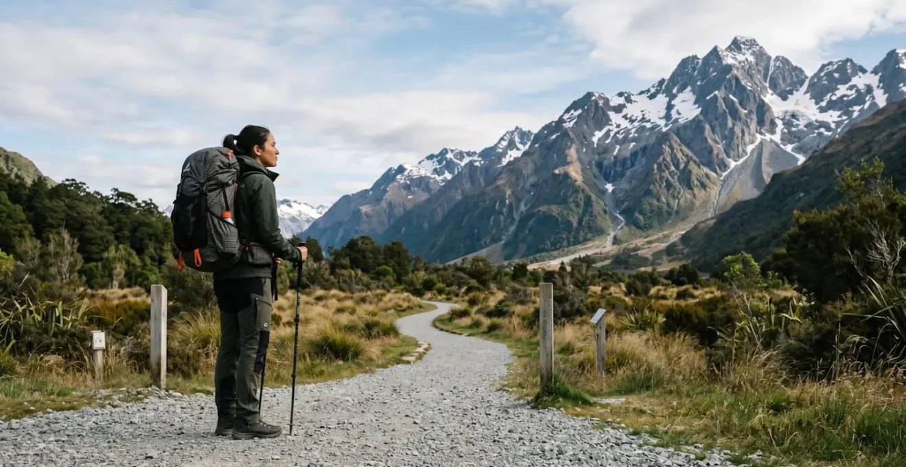
Contrary to popular belief, accessing the profound solitude of remote locations isn’t about owning a rugged 4×4 or mastering extreme survivalism. The real key is a shift in mindset: from relying on gear to mastering a few critical planning frameworks. This guide demystifies the process, showing how strategic preparation in areas like medical response, resource calculation, and environmental awareness empowers any motivated person to safely explore the wilderness.
For many urban dwellers, the idea of a truly remote escape feels like a distant dream, guarded by images of grizzled adventurers and heavily modified off-road vehicles. The desire for pristine nature and digital detox is strong, but the perceived barrier to entry—the need for specialized equipment and near-superhuman wilderness skills—can be deeply intimidating. We’re often told the solution lies in buying more: a bigger truck, a more advanced GPS, or a tent that can withstand a hurricane.
But what if this entire premise is flawed? What if the secret to unlocking the backcountry isn’t found in a gear catalogue, but in a mental toolkit? The true gatekeeper to the wild isn’t your vehicle, but your preparation. It’s about understanding and mitigating risk long before you ever lose cell service. It’s about out-thinking the challenges, not just hoping to out-muscle them.
This guide is built on that principle. We will dismantle the myth that remote travel is only for the elite adventurer. Instead of focusing on what to buy, we’ll focus on how to think. We will explore the non-negotiable planning frameworks that turn unknown fears into manageable variables, covering everything from medical preparedness and resource calculation to navigation and the progressive building of your own confidence and skill.
This article provides a detailed roadmap for your journey into the wild. Below is a summary of the key frameworks we will explore, designed to build your competence and confidence step by step.
Summary : A Practical Guide to Wilderness Access for the Modern Explorer
- Why Are Remote Locations Life-Threatening if You’re Unprepared for Medical Emergencies?
- How to Calculate Food and Water Needs for 5 Days in Remote Locations?
- Guided Expedition or Self-Drive Adventure: Which Suits Remote Locations Best?
- The Weather Ignorance That Strands Hikers in Remote Locations for Days
- When Can You Safely Access Remote Locations in Patagonia or Alaska?
- How to Navigate Wilderness Adventures With Map and Compass When Technology Fails?
- The Tidal Misjudgment That Traps 100+ People Annually in UK Seascapes
- How Can Beginners Transition From Day Hikes to Multi-Day Wilderness Adventures?
Why Are Remote Locations Life-Threatening if You’re Unprepared for Medical Emergencies?
The primary danger in remote locations isn’t dramatic events like animal attacks, but the insidious « cascade effect. » This is where a minor, easily treatable issue—like a blister, a twisted ankle, or mild dehydration—escalates into a life-threatening emergency simply because professional medical help is not minutes, but hours or even days, away. The isolation itself becomes the most significant risk factor.
In an urban environment, help is a quick phone call away. In the backcountry, that safety net vanishes. It’s a sobering reality that in many remote settings, organized wilderness emergency medical service response is unlikely to arrive on time, if at all. This delay multiplies the severity of any injury. A sprain that would mean a trip to an urgent care clinic at home can mean a life-threatening inability to move to safety in the wild, exposing you to weather and further injury.
Case Study: The Cascade Effect in Action
Epidemiological analysis of wilderness incidents reveals a clear pattern: catastrophic events are rare. The most common threats are minor afflictions that become severe due to the remote context. A hiker develops blisters but pushes on. The broken skin gets infected. Without the ability to properly clean and care for the wound, the infection worsens, potentially leading to sepsis. Simultaneously, the pain from the blisters causes an altered gait, leading to a fall and a sprained ankle. Now immobilized, dehydrated, and with a growing infection, the hiker is in a critical situation—all stemming from what began as a simple blister. This demonstrates how professional help being 24+ hours away transforms a nuisance into a medical emergency.
Therefore, preparation isn’t just about carrying a first-aid kit; it’s about having the knowledge to prevent minor issues from occurring (e.g., proper boot fit) and the skills to manage them effectively when they do, stopping the cascade before it begins. This includes basic wound care, splinting, and recognizing the early signs of dehydration and hypothermia.
How to Calculate Food and Water Needs for 5 Days in Remote Locations?
In the backcountry, water and calories are your lifeblood. Miscalculating your needs can lead to dehydration or exhaustion, both of which severely impair judgment and physical ability. The key is to adopt a « closed-system » planning approach, where every liter of water and every calorie is accounted for before you take your first step. This isn’t about guesswork; it’s about a simple, repeatable calculation.
Water is particularly critical and surprisingly heavy. As a baseline, you need to plan for about one liter of water for every two hours of hiking. However, this is just the starting point. You must then adjust for environmental factors like altitude, heat, and humidity, which can dramatically increase your body’s needs. The goal is to move from hoping you have enough to knowing you have a surplus.
This image of a meticulously planned water system symbolizes the precision required. For food, the challenge is balancing weight and energy. Since water weighs over 2 lbs per liter, and backpackers typically carry only about 2 lbs of food per day, every ounce of food must be calorically dense. This means prioritizing items like nuts, dried fruits, and specialized backpacking meals over heavier, water-filled options. Your plan must always include a non-negotiable buffer—at least two extra days of food and water—for unforeseen delays.
Your Action Plan: Water Calculation Framework
- Calculate Hiking Time: Estimate 30 minutes per mile on flat terrain, adding 30 minutes for every 1,000 feet of elevation gain to get your total hiking hours.
- Apply Base Rate: Plan to carry 1 liter of water for every 2 hours of hiking as your starting baseline.
- Add Environmental Buffer: Increase your total by 25% for high altitude (above 8,000 feet) and another 20% for high humidity conditions.
- Plan 48-Hour Emergency Buffer: After calculating your trip’s total water need, add a full two-day supply on top of that as a non-negotiable emergency reserve.
- Identify Water Sources: During your planning phase, use topographical maps and GPS layers to identify and verify reliable, year-round water sources along your route.
Guided Expedition or Self-Drive Adventure: Which Suits Remote Locations Best?
Choosing between an organized expedition and a self-guided adventure is a critical decision that shapes your entire experience. There is no single « best » answer; the optimal choice depends on your experience level, budget, and primary goal. Thinking of this as a strategic choice rather than a simple preference empowers you to perfectly match the trip style to your needs.
A guided expedition offers the immense benefit of local expertise. Guides handle the complex logistics—permits, navigation, and safety—allowing you to focus on the experience. They know the terrain, the weather patterns, and where to find wildlife. This is an excellent option for first-time visitors to a challenging region or anyone whose priority is learning and comfort. The trade-off is often cost and a lack of flexibility, as itineraries are typically fixed.
Conversely, a self-drive adventure provides ultimate freedom. You control the pace, the schedule, and every stop along the way. This is ideal for experienced travelers, photographers who need to wait for the perfect light, or anyone who craves the challenge and reward of total independence. However, it places all responsibility for planning, safety, and navigation squarely on your shoulders. It is often more budget-friendly but requires a significant upfront investment in research and preparation.
A more nuanced approach, the « hybrid model, » is gaining popularity. This strategy combines the best of both worlds. As the travel experts at Africa Unpacked note, this can be a powerful way to maximize an experience.
A popular approach is to self-drive Kruger for 4-5 days, then spend 2 nights at a guided Sabi Sands lodge for guaranteed leopard sightings and off-road access. This gives you the best of both worlds: independence and expert guiding.
– Africa Unpacked Travel Experts, Self-Drive vs Guided Safari Complete 2026 Comparison Guide
This hybrid model can be applied globally: self-drive to a remote region, then hire a local boat for last-mile access, or join a guided day-hike for a particularly challenging summit. The following table breaks down the core differences to help you make an informed choice.
| Factor | Guided Expedition | Self-Drive Adventure | Hybrid Model |
|---|---|---|---|
| Expertise Access | Professional guides with local knowledge and wildlife tracking skills | Independent navigation requiring prior research | Strategic guide hire for critical sections only |
| Cost Range | Higher investment with luxury amenities included | More budget-friendly, 40-60% lower than guided | Mid-range – guided portions + self-drive flexibility |
| Flexibility | Fixed itinerary tailored to group majority | Complete control over pace, stops, and schedule | Self-drive to region + local shuttle/boat for last-mile access |
| Wildlife Sightings | Higher success rate through guide network and tracking expertise | Dependent on personal skill and patience | Guided for key wildlife days, self-explore for landscapes |
| Best For | First-time visitors, comfort-seekers, learning focus | Experienced travelers, photographers, adventurers | Beginners wanting independence without full commitment |
The Weather Ignorance That Strands Hikers in Remote Locations for Days
One of the most common and dangerous mistakes beginners make is trusting a « valley forecast. » Checking the weather for the town at the base of a mountain range and assuming it applies at 10,000 feet is a recipe for disaster. Mountains create their own weather, and conditions can change from sunny and mild to a freezing blizzard with terrifying speed. Understanding this principle is non-negotiable for remote safety.
The most basic factor is temperature. As a rule, temperatures drop about 3°F for every 1,000 feet of vertical gain. A comfortable 70°F (21°C) in the valley could mean it’s near freezing on a 10,000-foot pass, even before accounting for wind chill. Wind accelerates this cooling effect and can turn a chilly day into a hypothermic threat. Beyond temperature, you must be aware of localized phenomena like afternoon thunderstorms in the Rockies or the ferocious, unpredictable winds of Patagonia.
Case Study: The Torres del Paine ‘Valley Forecast’ Tragedy
In November 2025, hikers on Chile’s famous O Circuit were caught in a catastrophic storm. The critical failure was a reliance on inaccurate weather information. Public apps and campground briefings—essentially valley forecasts—predicted strong but manageable 100kph winds. The actual gusts, however, reached over 200kph, flattening tents and creating whiteout conditions. With no dedicated weather stations on the remote backside of the range, hikers were completely unprepared. The event resulted in 27 medical evacuations and tragic loss of life, serving as a stark reminder that mountain-specific weather assessment is an absolute necessity for remote area safety.
The solution isn’t to become a meteorologist, but to learn to read basic environmental cues and use the right tools. This means checking mountain-specific forecasts from sources like the National Weather Service, understanding how to read a barometric altimeter for pressure changes, and recognizing visual signs of impending storms like lenticular clouds over peaks. It’s about maintaining a constant state of weather awareness, not just a single glance at your phone in the morning.
When Can You Safely Access Remote Locations in Patagonia or Alaska?
« When » you go is as important as « where. » The concept of a safe « access window » for remote locations is defined by two factors: predictable weather patterns and the operational season of essential services. Ignoring either can leave you stranded and cut off from help. Each remote region has its own unique character and set of primary threats that dictate this window.
For example, Patagonia and Alaska are both iconic wilderness destinations, but their dangers are different. Patagonia’s primary threat is the wind. It’s not just a breeze; it’s a relentless, powerful force that can exceed 200kph, capable of destroying gear and inducing extreme wind chill. In contrast, coastal Alaska’s key threat is often a combination of persistent, cold rain and near-freezing temperatures, a perfect recipe for hypothermia. Understanding the specific dominant threat of a region is the first step in planning a safe trip.
The second, and often overlooked, part of the access window is logistical. Your ability to safely visit a remote area is often directly tied to the operating dates of crucial infrastructure. This includes ferries, shuttle buses, ranger stations, and emergency services. Attempting to visit outside this peak season, even if the weather seems good, can be extremely risky. A study on wilderness medicine highlights that in remote settings, required medical and rescue resources are usually not available outside these established operational periods. If you get into trouble during the « shoulder season, » you may be truly on your own.
Therefore, planning a trip to a remote location requires you to research two calendars: the climatological one (when is the weather most stable?) and the logistical one (when are the services I depend on running?). The overlap between these two calendars is your safe access window. Venturing outside it isn’t adventurous; it’s reckless.
How to Navigate Wilderness Adventures With Map and Compass When Technology Fails?
The biggest myth about wilderness navigation is that you only need a map and compass when your GPS or phone fails. The truth is, you should be using them *before* your technology fails. This practice, known as preventative navigation, is a mindset that transforms your paper map from a last-resort backup into your primary tool for understanding the landscape. By constantly referencing your map while your GPS is still working, you build a mental model of the terrain, so if the screen goes blank, you’re merely orienting, not truly lost.
The consequences of poor navigation are severe. In a recent three-year period in the White Mountains, being lost or missing accounted for 42 percent of all rescue missions—an even greater number than injuries. This statistic underscores that navigation is not a peripheral skill; it is a core survival competency. The good news is that you don’t need to be a cartographer to be safe. Mastering a few key skills covers 80% of what you’ll need.
The most fundamental skill is orienting your map: aligning the map’s north with the compass needle’s direction. Once the map is oriented, the world around you should match the paper in your hands. From there, you can use powerful but simple techniques. One is « handrailing »—following a linear feature like a river, coastline, or ridgeline, which requires minimal compass work. Another is using your altimeter (on a watch or phone) as your primary tool in the mountains; often, knowing your elevation is more useful than knowing your exact coordinates.
This constant cross-referencing between the map, compass, and landscape is the heart of preventative navigation. Every time you reach a trail junction, you pull out the map. When you stop for water, you identify the peaks you can see. This active engagement prevents disorientation and builds a deep, intuitive connection to your surroundings that no app can replicate.
The Tidal Misjudgment That Traps 100+ People Annually in UK Seascapes
One of the most powerful mental models for remote safety is the concept of « environmental one-way doors. » These are situations where you can easily proceed in one direction, but natural forces will soon shift to make a return journey difficult or impossible. The classic example is a coastal walk to a beautiful sea cave that is accessible at low tide but becomes completely cut off by water when the tide comes in. Hundreds of people are rescued from such situations annually, not because they are weak hikers, but because they failed to respect a one-way door.
This trap is often sprung by a psychological bias known as « destination fever. » As researchers note, this is a powerful force.
Destination fever creates an optimism bias that makes people ignore the clock. The desire to reach a specific sea cave or beach causes hikers to push beyond their calculated point of no return time.
– UK Coastal Safety Researchers, Analysis of coastal rescue patterns
The solution is to replace desire with discipline. Before starting, you must consult a tide chart, determine the time of low tide, and calculate a non-negotiable turnaround time. This time is your hard stop, regardless of whether you’ve reached your scenic destination. Setting a loud alarm on your phone or watch can be an effective way to enforce this discipline against the pull of destination fever.
The « one-way door » principle applies to many other environments beyond the coast:
- Slot Canyons: Entering a canyon is easy, but a distant thunderstorm can trigger a flash flood, making retreat impossible. You must exit before the daily afternoon storm window.
- High Mountain Passes: Crossing a pass is often safest in the morning before the sun melts snow bridges and before the risk of afternoon lightning storms increases. Descending in a lightning storm is a one-way trip you don’t want to take.
- Desert Trails: An exposed desert crossing may be pleasant at dawn, but midday heat can make the return journey dangerously dehydrating. You must complete the section before the heat becomes a one-way commitment.
Recognizing and respecting these environmental one-way doors is a hallmark of an experienced and safe outdoor adventurer. It is a mental skill that is far more valuable than any piece of gear.
Key Takeaways
- Wilderness safety is primarily a result of meticulous planning and risk mitigation, not expensive gear or elite physical fitness.
- Mastering mental models like the « Cascade Effect » and « Environmental One-Way Doors » is more effective than simply carrying a first-aid kit.
- True competence is built progressively through a « Competency Ladder, » starting with safe, low-stakes experiences to test skills and gear before committing to a remote expedition.
How Can Beginners Transition From Day Hikes to Multi-Day Wilderness Adventures?
The leap from a comfortable day hike to your first overnight wilderness trip can feel monumental. The key is to reframe it not as a single leap, but as a series of manageable steps on a « Competency Ladder. » This progression model allows you to build skills, test gear, and grow your confidence in a controlled, safe way, ensuring your first multi-day adventure is a success, not a struggle.
This journey requires conquering not just the physical challenges, but also what can be called the « Psychological Trio » of beginner anxieties: fear of wildlife and darkness, fear of gear failure, and fear of disconnection. The Competency Ladder is designed to address each of these fears systematically. For instance, starting with car camping in a populated campground (Level 1) helps you get used to the sounds of the night while knowing other people are nearby. The critical « shakedown hike » (a key step between levels) addresses gear anxiety by forcing you to test your fully loaded pack on a difficult day hike, revealing any discomfort or problems before you’re committed to an overnight stay far from your car.
This structured progression turns the overwhelming goal of « going backpacking » into a series of achievable milestones. Each level builds upon the last, layering skills and experience until you are ready for your first true wilderness trip.
Your Action Plan: The Competency Ladder Progression Model
- Level 1: Car Camping with Ambitious Day Hikes. Build your hiking stamina and get used to being outdoors, with the safety and comfort of your vehicle to return to each night.
- Level 2: Backyard or Local Park Overnight ‘Shakedown’. Test your tent, sleeping bag, and cooking system in a completely safe and accessible environment. Work out the kinks close to home.
- Level 3: Hut-to-Hut or Refuge-to-Refuge Trek. Experience multi-day travel logistics and sleeping away from home, but with shelter and meals managed by others. This focuses you on the hiking aspect.
- Level 4: First One-Night Wilderness Trip. Choose a well-marked, popular trail near a road for your first solo or self-sufficient overnight trip. This combines all your skills with a short commitment.
- Critical Step: The Shakedown Hike. Before Level 4, complete a demanding 5-10 mile day hike while carrying your fully loaded multi-day pack. This is the single most important step to test your gear, your fitness, and your mental resolve.
By following this ladder, you are not just preparing for a trip; you are systematically building the competence and self-reliance that define a true wilderness traveler. You are proving to yourself, step by step, that you have what it takes.
Your journey into the wild begins not with a purchase, but with a plan. Start by taking the first step on your personal Competency Ladder today. Assess your current level and plan your next small, achievable adventure.