In summary:
- Peak seasonal displays (like fall color) are a brief 1-2 week event, not a months-long phenomenon, driven by specific biochemical triggers.
- Successfully timing your visit requires a data-driven « intelligence triangulation » of predictive maps, real-time social media reports, and live webcams.
- Build a 3-5 day « weather buffer » into your travel plans, arriving just before the predicted peak to avoid being foiled by a single storm.
- For guaranteed conditions in a changing climate, prioritize destinations where seasonal events are tied to stable factors like high elevation or northern latitude.
- Beyond the season, mastering the « reverse schedule »—arriving before opening or during blue hour—is key to avoiding crowds at popular landmarks.
For landscape photographers and nature lovers, the ultimate prize is capturing a location at its absolute seasonal zenith: the explosive peak of autumn foliage, the ephemeral blush of spring wildflowers, or the pristine blanket of fresh winter snow. Yet, so often, these trips result in disappointment. You arrive a week too late to find bare branches, or a week too early for a sea of green. The common advice— »go in October for fall colors »—is dangerously simplistic and a primary cause of missed opportunities.
Many travelers rely on historical averages or generic weather forecasts, but these tools are increasingly unreliable in a changing climate and fail to capture the hyper-local variations that define peak conditions. The truth is that nature’s most spectacular displays are not a long, lazy season but a fleeting, dramatic event. The key to success isn’t luck; it’s shifting your mindset from that of a passive tourist to an active intelligence operative tracking nature’s own clock.
This guide moves beyond the platitudes to arm you with a phenology-informed strategy. We will dissect the science that dictates the timing of these peaks, provide a framework for monitoring conditions in real-time, and offer concrete tactics for building resilience and flexibility into your travel planning. You will learn how to turn unpredictability into a strategic advantage, ensuring your next trip puts you in the right place at the right time for that picture-perfect shot.
This comprehensive guide details the expert strategies for timing your visits to natural wonders. From understanding the science of seasonal change to tactical planning for avoiding crowds, you’ll find everything you need to capture nature at its most spectacular.
Table of Contents: Timing Your Visit for Spectacular Natural Scenery
- Why Do Autumn Colors in Natural Scenery Last Only 2 Weeks, Not All September-October?
- How to Monitor Natural Scenery Bloom and Color Reports Before Booking Travel?
- Long Season or Dramatic Peak: Which Natural Scenery Type Suits Flexible Versus Fixed Travel Dates?
- The Week-Too-Late Mistake That Ruins Natural Scenery Photography Plans
- Which Natural Scenery Destinations Have Predictable Seasonal Peaks Despite Climate Change?
- When Should You Photograph Popular Landmarks to Avoid 100 People in Your Holiday Photos?
- How to Choose Winter Destinations With Guaranteed Snow in a Warming Climate?
- What Can Non-Skiers Do in Winter Destinations Besides Sitting in the Lodge?
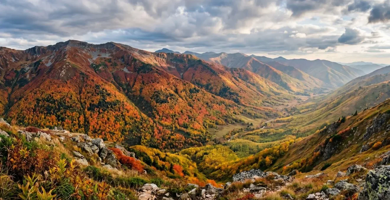
Why Do Autumn Colors in Natural Scenery Last Only 2 Weeks, Not All September-October?
The notion that autumn color is a months-long spectacle is a common misconception that leads to disappointment. In reality, the « peak » is a brief, intense biochemical event lasting roughly two weeks in any specific location. This fleeting window is not dictated by the calendar, but by a precise sequence of environmental cues and chemical reactions within the leaves. The process is a finely tuned race against time, making accurate prediction both a science and an art.
The primary trigger is decreasing daylight, not just temperature. As days shorten, trees begin to form a corky abscission layer at the base of each leaf stem. This layer gradually chokes off the flow of water and nutrients, effectively signing the leaf’s death warrant. Once this process begins, the vibrant green chlorophyll, which masks other pigments, stops being produced and breaks down. This reveals the yellow and orange carotenoids that were present all along. For the coveted reds and purples to appear, specific weather conditions are required: sunny days and cool, crisp nights (between 32-45°F) allow the tree to produce anthocyanin pigments from trapped sugars. This delicate combination of factors is why a single warm spell or cloudy week can result in a muted, yellow-dominant season.
Furthermore, elevation plays a critical role in this timing. A key principle of phenology is that conditions change predictably with altitude; a phenomenon where peak colors shift by about one week for every 1,000 feet of elevation. This explains why mountainsides display a cascading wave of color from summit to valley. To truly understand this process, one must appreciate the specific steps that turn a forest from green to gold.
The Biochemical Color Cocktail Sequence
- Trigger: Shorter daylight triggers corky abscission layer formation between leaf and stem, cutting off the leaf’s nutrient support system.
- Chlorophyll Breakdown: Chlorophyll production halts and existing green pigment breaks down over several days.
- The Unmasking: Yellow and orange carotenoids, which were present all along but masked by green, become visible.
- Red Production: Anthocyanins develop from remaining sugars under optimal conditions (sunny days, cool nights 32-45°F), creating red and purple hues.
- The Finale: Weather events like heavy wind, rain, or a hard frost can strip the leaves from the trees almost overnight, abruptly ending the display.
How to Monitor Natural Scenery Bloom and Color Reports Before Booking Travel?
Relying on historical data alone is a recipe for failure in our current climate. To accurately predict and intercept peak conditions, you must adopt a multi-source intelligence gathering strategy, a method I call « Intelligence Triangulation. » This involves actively monitoring three distinct categories of information—predictive, real-time, and visual—to build a comprehensive and dynamic picture of what’s happening on the ground. No single source is infallible, but by cross-referencing them, you can dramatically increase your chances of success.
The first pillar is official predictive maps, like those from state forestry services or dedicated sites like SmokyMountains.com. These are your strategic, long-range forecasts. They use a combination of historical data, meteorological models, and phenological principles to project when peak conditions are likely to occur across a region. While powerful, they are best used for initial planning, as their broad predictions can shift with evolving weather patterns.
The second, and perhaps most crucial, pillar is real-time social media. This is your ground truth. By searching geotags and hashtags (e.g., #fallfoliage, #peakcolor) on platforms like Instagram and Flickr and filtering by « Most Recent, » you can see unfiltered photos and videos from other visitors, often posted within hours. This provides hyper-local evidence of current conditions, revealing nuances that broad predictive maps miss. Finally, live webcams from national parks, ski resorts, or local visitor bureaus offer real-time visual confirmation, removing any subjective interpretation. They are the ultimate « eyes on the ground » before you commit.
This combination of predictive models, human intelligence, and direct visual evidence forms a robust system. By triangulating these sources, you can confidently adjust your plans, identify micro-locations that are peaking, and avoid the disappointment of arriving at the wrong time. A structured approach is essential for making sense of this data flood.
This following table breaks down the three-source monitoring strategy, highlighting the strengths and weaknesses of each component, which is crucial for any photographer or traveler planning a trip as documented in a recent comparative analysis of tracking tools.
| Source Type | Tools/Platforms | Strengths | Limitations | Update Frequency |
|---|---|---|---|---|
| Official Predictive Maps | SmokyMountains.com map, ExploreFall.com, state forest services | Science-based forecasting using meteorology and historical data; regional coverage | Predictions can shift with weather changes; too broad for micro-locations | Daily to weekly updates |
| Real-Time Social Media | Instagram/Flickr with date filters and geotags; hashtags like #fallfoliage #peakcolor | Unfiltered ground truth from actual visitors; hyper-local conditions; photo evidence | Popular old photos may appear in results; requires filtering by ‘Most Recent’ | Continuous (hourly) |
| Live Webcams | National park webcams, ski resort cameras, visitor center feeds | Real-time visual confirmation; no subjective interpretation; 24/7 access | Limited viewpoints; weather/lighting can obscure view; not all locations have webcams | Real-time (streaming) |
Long Season or Dramatic Peak: Which Natural Scenery Type Suits Flexible Versus Fixed Travel Dates?
Not all seasonal phenomena are created equal. Understanding the difference between « long season » and « dramatic peak » events is crucial for aligning your travel style with the right destination. Your level of schedule flexibility dictates which type of scenery you should target. For travelers with fixed vacation dates—often booked months in advance—targeting a dramatic peak event like cherry blossoms or alpine wildflowers is a high-risk, high-reward gamble. Since these peaks can shift by weeks due to weather, fixed-date travelers are better served by targeting « long season » destinations.
Long season environments are those where the beautiful conditions persist for an extended period. Examples include the rolling lavender fields of Provence, which bloom for over a month, or the coastal scenery of the Pacific Northwest, where misty, dramatic conditions are a reliable feature throughout the fall and winter. For fixed-date travelers, these destinations offer a high probability of experiencing the desired atmosphere, even if it’s not a singular, explosive « peak » moment. The goal is to maximize the chance of success within a constrained timeline.
Conversely, travelers with flexible schedules are perfectly positioned to chase « dramatic peak » events. This flexibility is a strategic asset that allows for the « Cascade of Peaks Strategy. » Instead of locking into one location, you can plan a trip around a region with varied elevations. As peak foliage progresses, you can move up or down in altitude to « chase » the color wave, maximizing your time in optimal conditions. This approach is particularly effective for fall foliage, as analysis shows that while more than 80% of fall foliage trips are concentrated in October, the actual peaks are spread across different elevations and latitudes from September to November.
The Cascade of Peaks Strategy – Following the Fall Color Wave
Flexible travelers can maximize their peak foliage experience by planning multi-elevation itineraries. The 2025 foliage forecast reveals a predictable progression pattern: travelers use interactive maps to identify peak timing for their target region, then build backup plans at one elevation band higher and one lower. For example, if the White Mountains show near-peak in mid-October, the backup strategy includes Franconia Notch (higher elevation, earlier peak) and Blue Ridge Parkway (lower elevation, later peak). This elevation-layered approach allows travelers to chase optimal conditions by adjusting their route in real-time based on updated reports, transforming unpredictability into a strategic advantage for those with flexible schedules.
The Week-Too-Late Mistake That Ruins Natural Scenery Photography Plans
Perhaps the most painful experience for a nature photographer is arriving to find a scene of barren branches and a carpet of brown leaves—the ghost of a peak that occurred just days earlier. This « week-too-late » mistake is incredibly common, and it stems from a single planning flaw: timing your arrival for the exact predicted peak date. While this seems logical, it leaves zero margin for error against nature’s most disruptive force: weather. A single day of high winds or a heavy rainstorm can strip a forest of its foliage overnight, ending the show prematurely.
As the experts at Parade Travel have noted, the window is incredibly tight; you can « miss it by a week and you could find yourself staring at some patchy branches. » The strategic solution is to build a « Weather Buffer Window » into your itinerary. Instead of aiming to arrive on the day of the predicted peak, plan to arrive 3-5 days before. This buffer serves two critical purposes. First, it provides insurance against a sudden, weather-induced end to the season. If a storm is forecast, you’ll have already had several days of shooting in near-peak conditions.
miss it by a week and you could find yourself staring at some patchy branches
– Parade Travel Experts, Best Fall Foliage Maps to Track Peak Leaf Color in 2025
Second, this « pre-peak » shoulder period offers its own unique advantages. The crowds are often thinner, and travel costs may be lower. Photographically, this « first blush of color » provides a different but equally beautiful aesthetic, with vibrant reds and yellows set against a backdrop of remaining green, creating more complex and dynamic compositions. Embracing this buffer strategy requires a shift in mindset: the goal is not just to hit the absolute peak, but to maximize your opportunities for great photography within the peak’s volatile window.
Weather Buffer Strategy – Timing Arrival Before Peak
- Identify Peak Date: Identify your target region’s predicted peak date using real-time foliage maps, not just historical averages.
- Monitor Weather: Monitor extended weather forecasts 10-14 days out for windstorm warnings or heavy precipitation events.
- Plan Buffer: Plan arrival 3-5 days before the predicted peak to create a weather buffer window.
- Maintain Flexibility: Avoid solidifying plans until you’re within two weeks of peak foliage to maintain flexibility against extreme weather disruptions.
- Embrace Pre-Peak: If you arrive early, embrace the ‘pre-peak’ shoulder period which offers fewer crowds, lower costs, and the unique aesthetic of ‘first blush of color’ photography.
Which Natural Scenery Destinations Have Predictable Seasonal Peaks Despite Climate Change?
As climate change accelerates, the predictability of many beloved seasonal events is decreasing. Warmer autumns delay and mute fall colors, while unseasonable spring warmth can cause flowers to bloom and fade before travelers can react. For example, rigorous scientific modeling shows that cherry blossom peak bloom dates are accelerating by an average of 5 days by the 2050s under mid-range emissions scenarios. This growing unpredictability makes planning more challenging. However, certain types of destinations remain remarkably consistent because their seasonal clocks are tied to more stable environmental factors than just ambient temperature.
The most reliable destinations are those where seasonal events are dictated by high elevation or high latitude. In these environments, the primary drivers of change are the immutable angle of the sun and drastic temperature drops that are less affected by overall warming trends. High-altitude alpine environments, for instance, have predictable windows for wildflower blooms (immediately following snowmelt) and the turning of larch trees, as their life cycles are governed by a harsh, short growing season dictated by elevation. Similarly, northern latitude destinations offer reliable fall color from species like aspen and birch, which respond more to daylight cues than to temperature fluctuations.
These climate-resilient locations offer a strategic advantage for photographers and travelers seeking reliable conditions. By targeting landscapes above the treeline or in boreal regions, you can hedge your bets against the volatility seen at lower elevations and more temperate latitudes. The stark, dramatic beauty of these places is a product of their resilience. They are environments where the timeless geological and solar cycles still hold sway over a shifting climate, offering a welcome degree of predictability in an uncertain world.
In essence, to find predictability, one must seek out environments where the seasonal script is written by forces more powerful than short-term weather. The mountains and the far north remain the most trustworthy keepers of nature’s calendar, providing a reliable canvas for capturing seasonal beauty year after year. These locations demonstrate that even with global changes, some natural rhythms endure, offering refuge for planned seasonal exploration.
When Should You Photograph Popular Landmarks to Avoid 100 People in Your Holiday Photos?
Timing your visit isn’t just about seasons; it’s about the time of day. Nothing ruins a majestic landscape photo more than a crowd of tourists in the frame. The common advice to « go early » is a good start, but true crowd avoidance requires a more tactical approach: the « Reverse Schedule Technique. » This method involves actively researching and planning your visit to coincide with the moments just outside of peak visitor traffic, which is surprisingly predictable.
The first step is to research the landmark’s precise opening and closing times, as well as the schedules of major tour bus companies that service the area. Most large tours operate on a standard mid-morning to late-afternoon schedule. By planning to arrive 30-60 minutes before the official opening time, you can often be one of the first people through the gates, granting you a precious window of solitude. Similarly, lingering for 30 minutes or more after the last tour bus departs can yield a quiet, golden-hour landscape. For sunrise shots, this requires scouting the location the evening before to find your exact composition spot, ensuring you don’t waste valuable time in the dark.
shoulder seasons, just before or after the busiest times, often offer gorgeous scenery without the overwhelming crowds
– National Park Guide, Best National Parks for Seasonal Photography
Beyond the daily schedule, mastering the « blue hour »—the brief period of soft, diffused twilight just before sunrise or after sunset—is a photographer’s secret weapon. The cool, moody light creates a dramatic atmosphere entirely different from the harsh midday sun. More importantly, these are times when most tourists are either still in bed or at dinner. By aligning your photography sessions with these blue hour windows, you not only capture unique lighting conditions but also ensure your frame is free of unwanted distractions. This disciplined approach transforms crowd management from a hopeful wish into a deliberate strategy.
The Reverse Schedule Technique for Crowd-Free Photography
- Research Hours: Research the landmark’s official opening hours and identify the precise first entry time.
- Track Tours: Investigate major tour bus company schedules for that location (most arrive mid-morning, depart late afternoon).
- Target the Edges: Plan to arrive 30-60 minutes before official opening or 30+ minutes after the last tour bus departure.
- Scout in Advance: For sunrise shots, scout the location the evening before to identify your exact composition spot and required arrival time.
- Master Blue Hour: Master blue hour timing (just before sunrise or after sunset) for dramatic moody shots with cooler diffused light and minimal crowds.
How to Choose Winter Destinations With Guaranteed Snow in a Warming Climate?
For winter enthusiasts and photographers, the fear of a « green winter » is becoming increasingly real. As global temperatures rise, a reliable, deep snowpack is no longer a given in many traditional winter destinations. However, just as with fall colors, certain geographical factors create « snow-sure » havens that remain dependable. The key is to prioritize destinations where snow reliability is dictated by the unwavering principles of altitude and geography over fickle temperature forecasts.
The first rule is simple: altitude trumps latitude. A high-elevation destination will almost always be more snow-sure than a low-elevation one, even if the latter is further north. This is because altitude provides the consistent cold temperatures necessary for both receiving and retaining snow. A real-world example starkly illustrates this: New York City and parts of Rocky Mountain National Park share the same latitude, yet their seasonal changes are months apart purely due to elevation-driven temperature differences. While NYC’s winter becomes less predictable, high-altitude parks maintain their deep snowpack.
The second principle is to look for specific geographical features that act as natural snow traps. North-facing slopes are prime targets, as they receive significantly less direct sunlight, which dramatically slows the melting process. These shaded aspects can hold deep, high-quality snow for weeks or even months longer than their sun-drenched south-facing counterparts. Additionally, areas with dense conifer forests are excellent for snow retention. The tree canopy catches falling snow, and the shade it provides protects the snowpack on the ground from the sun. By targeting destinations that combine high elevation with an abundance of north-facing, forested terrain, you are stacking the odds for a picturesque winter landscape in your favor.
Altitude and Latitude Rule Applied – Rocky Mountain National Park vs NYC
New York City and Rocky Mountain National Park both lie at 40.7°N latitude, experiencing identical daylight changes. Despite this, they experience peak seasonal changes nearly two months apart due to temperature differences driven by elevation. September nights in Rocky Mountain National Park average nearly 30 degrees cooler than NYC, bringing peak color as early as September 20th at high elevations, while NYC doesn’t see peak until November. This real-world case study, as detailed by forecasters at ExploreFall, demonstrates that for winter snow reliability, altitude trumps latitude: high-elevation destinations maintain consistent snow conditions even as lower-elevation areas at the same latitude face increasing variability due to warming climate.
Key takeaways
- Peak seasonal moments are brief, 1-2 week events driven by specific environmental triggers, not a month-long guarantee.
- Success requires active monitoring using a triangulation of predictive maps, real-time social media, and live webcams.
- In a warming climate, the most predictable seasonal events are tied to stable factors like high elevation and northern latitude.
What Can Non-Skiers Do in Winter Destinations Besides Sitting in the Lodge?
A common misconception is that a winter mountain destination offers little for those who don’t ski or snowboard. This outdated view misses a fundamental shift in winter travel: the rise of « atmosphere-centric » experiences that celebrate the season’s quiet beauty and cozy culture. For the non-skier, a winter landscape is not a playground to be conquered at speed, but an environment to be explored with intention and all five senses. The focus moves from adrenaline to immersion.
One of the most rewarding approaches is to embrace « silent sports. » These are human-powered activities that allow for a deep, quiet connection with the frozen landscape. Snowshoeing, for instance, allows you to venture into silent, snow-laden forests, exploring trails inaccessible to skiers. Timing these outings for the blue hour just after sunset can be a magical experience, as the snow takes on an ethereal blue glow. For a different perspective, icefall hiking with crampons under the guidance of a professional can reveal the stunning architecture of frozen waterfalls. Even a simple winter walk focused on macro photography can uncover a universe of intricate ice crystals and frost patterns.
Beyond physical activities, the « cozy culture » of winter offers its own rich itinerary. This approach reframes the trip around wellness and contemplative experiences. A perfect day might involve a Nordic spa, with its invigorating sequence of hot saunas and cold plunges, followed by an afternoon browsing a local bookshop or art gallery in a quaint mountain village. The evening could be spent at an intimate concert or enjoying a mountaintop fondue dinner accessible only by gondola. This shifts the goal of winter travel from what you *do* to how you *feel*, celebrating the contemplative, restorative qualities of the season itself.
Cozy Culture Itinerary – Wellness-Focused Winter Experience
Winter destinations increasingly cater to non-skiers through experience-based itineraries that embrace the season’s unique culture rather than just its sports. A model itinerary combines Nordic spa experiences (featuring signature hot/cold plunge sequences that leverage natural winter temperatures), afternoon browsing through independent mountain village bookshops and local artist galleries, evening attendance at intimate winter concert series or storytelling events, and culinary experiences like mountaintop fondue dinners accessible by gondola or ice wine tastings at nearby vineyards. This approach reframes winter travel from activity-centric to atmosphere-centric, creating rich experiences that celebrate the season’s cozy, contemplative qualities while maintaining connection to the winter landscape.
Ultimately, successfully timing your visit for picture-perfect seasonal conditions is about a fundamental shift in perspective. It requires moving from a passive tourist to an engaged observer who understands the science, uses modern tools, and embraces a strategic mindset. By learning to read nature’s calendar, you don’t just increase your chances of getting the perfect shot—you forge a deeper connection with the landscapes you seek to capture.