Looking at a historic harbour and seeing only « old buildings » is a missed opportunity. The key to unlocking their rich stories is to read them not as static museums, but as dynamic tidal ecosystems. By learning to decode clues in their architecture, materials, and even the rhythm of the tides, you can uncover a hidden history of immense wealth, brutal exploitation, and resilient living culture that most visitors never see.
You stand on the edge of a historic harbour, the salty air thick with the cries of gulls and the faint scent of diesel. Before you lies a postcard scene: weathered warehouses, stone quays, and boats bobbing on the water. For many, the experience stops here—a pleasant, but shallow, appreciation of « old things. » We’ve been taught to look for grand custom houses and visit the maritime museum, but this approach often leaves us feeling like we’re looking at a history book through thick glass.
The common advice is to admire the architecture, but it rarely tells you *how* to read it. What if the most profound stories aren’t just in the buildings, but in the spaces between them? What if the key to understanding the harbour’s soul lies not in its prettiest facades, but in the very rhythm of the tide that fills it twice a day? The truth is, a historic harbour is a palimpsest, a manuscript of stone and water where layers of history have been written, erased, and written over again. It is a living ecosystem of human stories.
This guide proposes a new way of seeing. Instead of merely observing, you will learn to decode. We will move beyond the obvious to understand how brickwork tells time, how the height of a quay reveals the secrets of the tide, and how the ghost of immense wealth is often inextricably linked to the shadow of human suffering. You will learn to distinguish a living, breathing port from a gentrified marina, and transform your next coastal visit from a passive sightseeing trip into an active historical investigation.
This article provides a structured approach to reading the complex narrative of any historic port. From identifying the materials that date an era to understanding the profound impact of natural forces, you will gain the tools to experience these places as the living history they truly are.
Summary: Reading the Layers of a Harbour’s Past
- How to Identify Which Century a Historic Harbour Was Most Active by Its Buildings?
- Which Historic Harbours Were Major Slave Trade Ports?
- Converted Marina or Active Fishing Port: Which Historic Harbours Preserve Authentic Maritime Culture?
- The Tidal Ignorance That Makes 40% of Historic Harbours Visits Visually Disappointing
- Which Historic Harbours Offer World-Class Maritime Museums?
- How to Decode the 5 Historical Eras Visible in Ancient Cities’ Architecture?
- Why Do Atlantic Sea Cruises Cause More Seasickness Than Mediterranean Routes?
- How to Experience Ancient Cities as Living History Instead of Open-Air Museums?
How to Identify Which Century a Historic Harbour Was Most Active by Its Buildings?
The story of a harbour’s busiest era is written in its very construction materials. Long before plaques and signposts, the bricks, mortar, and ironwork of a port tell a clear tale of its technological and economic peak. To the trained eye, a wall is not just a wall; it’s a timeline. The earliest harbour structures, dating back to antiquity, set a foundation for this layered history, with archaeological evidence of at least 950 ports in ancient coastal settlements.
The industrial revolution, however, marks the most dramatic shift. Pre-1870 buildings often feature hand-molded bricks with charmingly irregular shapes, sometimes even bearing the faint impression of the brick-maker’s fingers. The mortar between them is typically lime-based, appearing soft, crumbly, and pale. This was the age of local materials and manual labour.
A stark change occurs between 1870 and 1920. The introduction of mechanical brick presses and wire-cutting technology produced bricks of uniform size and sharp edges. This uniformity allowed for thinner, stronger mortar joints and faster construction, signaling an era of rapid industrial expansion. Look for the tell-tale parallel drag lines on the face of these wire-cut bricks. After 1920, extruded bricks with their smooth, almost plastic texture and cored holes (to save material) become common, often paired with hard, grey Portland cement mortar.
Beyond bricks, look for the infrastructure of industry. The presence of cast-iron pillars in warehouse construction or embedded railway lines running along the quaysides are definitive markers of 19th-century confidence and the need to move massive quantities of goods directly from ship to train. These elements are the physical manifestation of a port at the height of its industrial power.
Your Action Plan: Dating Port Construction Materials
- Pre-1870 Check: Look for hand-molded brick with irregular dimensions, visible fingerprints, and wide color variation. Test mortar with a fingernail; if it’s soft and crumbly (lime-based), it’s likely pre-1920.
- 1870-1920 Check: Identify mechanically pressed bricks with uniform dimensions and sharp edges. Spot wire-cut bricks by their parallel drag lines and thinner (8-12mm) mortar joints.
- Post-1920 Check: Find extruded bricks with a smooth, plastic-like texture and three uniform holes (cores) running through them. Confirm with the presence of hard, grey Portland cement-based mortar.
- Industrial Infrastructure Scan: Search for cast-iron pillars supporting buildings and look for railway lines embedded directly into the cobblestones or pavement of the quaysides.
- Synthesize Findings: Combine your observations. A quay with uniform bricks, cast-iron crane bases, and rail lines tells a clear story of a late 19th-century industrial boom.
Which Historic Harbours Were Major Slave Trade Ports?
Many of Europe’s most beautiful and seemingly genteel historic harbours hold a dark and often unspoken secret: their grandeur was financed by the transatlantic slave trade. This brutal enterprise, in which 12.5 million Africans were forcibly loaded onto ships over 366 years, was not a fringe activity but a central pillar of the Atlantic economy. The immense profits it generated were not hidden away; they were proudly displayed in the very fabric of the port cities that grew rich from it.
The architectural evidence is often hiding in plain sight. When you see a waterfront lined with unusually grand and ornate merchant mansions, or a « merchant quarter » with opulent townhouses far exceeding the needs of simple trade, you must ask where the money came from. Cities like Nantes in France and Bristol in England did not become powerful by trading wool and wine alone; their wealth was built on the « triangular trade » of guns for people, and people for sugar and cotton.
This « palimpsest of power » is visible everywhere if you know how to look. The case of Britain is particularly revealing. Birmingham became a global center for manufacturing the very guns traded for enslaved people. Manchester’s 19th-century boom was fueled by processing cotton picked by enslaved hands in the Americas. And in London, the vast profits from sugar plantations bankrolled the city’s burgeoning and lucrative coffee house culture. The elegant facades of these cities are a direct legacy of this system, their beauty a chilling testament to a history of exploitation.
Case Study: The Architectural Footprint of Triangular Trade
The cities of Nantes, France, and Bristol, England, offer stark examples of how triangular trade wealth was directly converted into architectural status. Both cities experienced a boom in the 18th century, developing grand merchant quarters and warehouses financed by the immense profits from the slave trade. In Bristol, a walk through the Queen Square area reveals magnificent Georgian townhouses built by merchants who grew rich from slave-produced sugar and tobacco. Similarly, the Île Feydeau in Nantes is an island of opulent 18th-century mansions, built on a swamp, a testament to the sheer scale of the wealth slave traders were willing to invest to display their status. These architectural ensembles are not just historic districts; they are monuments to the economic engine of the slave trade.
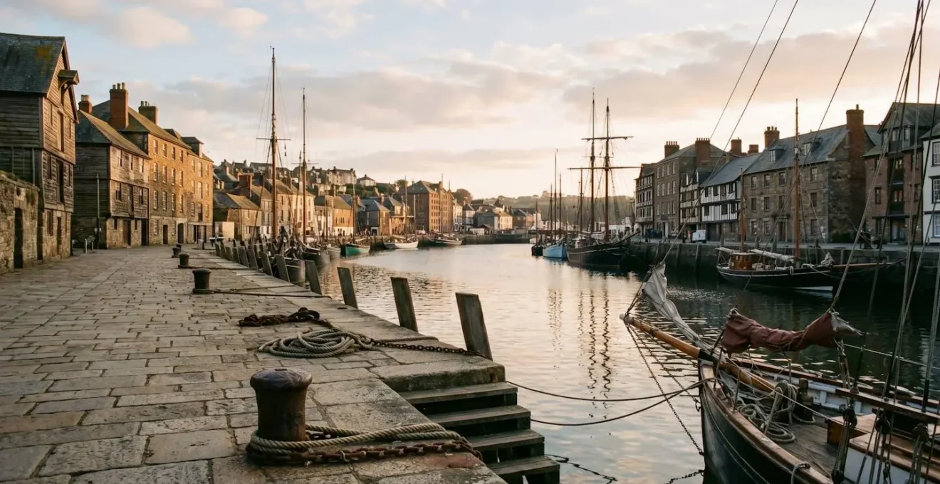
Converted Marina or Active Fishing Port: Which Historic Harbours Preserve Authentic Maritime Culture?
As you wander through a historic harbour, a crucial question arises: are you in a living community or a maritime-themed museum? Many historic ports have been converted into polished marinas, dominated by leisure yachts, waterfront condos, and seafood restaurants catering exclusively to tourists. While pleasant, these places have often lost their authentic maritime soul. The real magic lies in discovering a « working ecosystem, » where the culture of the sea is not a performance but a daily reality.
To distinguish between the two, you must look for the unglamorous but essential machinery of a working port. The first sign is the presence of ship chandleries—shops that smell of rope and tar, selling not tourist trinkets but marine supplies, navigation equipment, and heavy-duty workwear. Look for net-mending sheds, often just open-sided structures where fishermen are actively repairing their gear. An authentic fishing port needs an ice factory for preserving catches and will have active boat repair yards, slips, or even small-scale shipbuilding facilities—places filled with the sounds of grinders and the scent of resin.
The culture also lives in the language. Listen to the names of the pubs. A « Rope & Anchor » or « Shipwright’s Arms » is a good sign, hinting at a deep-rooted maritime vernacular. This concept of a living port is so important that it has been formally recognized. As the experts at National Historic Ships UK state in their initiative to protect these areas:
Heritage Harbours are places of historic maritime significance that retain original features, buildings and facilities important for supporting historic vessels and maritime skills, which help connect the public to the UK’s maritime past.
– National Historic Ships UK, Heritage Harbours Initiative Joint Statement
Ultimately, a truly authentic historic harbour is a place of industry. Look beyond the waterfront restaurants for the fish auction hall or the processing facilities. These elements confirm that the harbour’s connection to the sea is one of genuine work and livelihood, not just curated nostalgia.
The Tidal Ignorance That Makes 40% of Historic Harbours Visits Visually Disappointing
One of the most overlooked yet powerful forces shaping a historic harbour is the tide. Many visitors, oblivious to its daily rhythm, experience a visually disappointing visit, arriving at low tide to find a muddy, empty basin instead of the picturesque water-filled scene they expected. This isn’t a flaw; it’s a fundamental feature of the tidal ecosystem. Understanding the tide is not just practical planning; it’s key to unlocking major architectural and archaeological secrets.
In ports with a large tidal range, the engineering required to overcome this daily fluctuation is monumental. The historic port of Liverpool, for instance, had to contend with a massive 21-foot tidal range on the River Mersey. For ships to load and unload cargo efficiently, they needed a constant water level, a challenge that made traditional open quays impractical. This problem sparked a world-changing innovation.
Case Study: Liverpool’s Tide-Defying Engineering
Faced with the massive tidal range of the River Mersey, Liverpool’s engineers developed a groundbreaking solution. In 1715, they opened the Old Dock, the world’s first commercial wet dock. This was essentially a large, artificial basin sealed off from the river by lock gates. Ships could enter at high tide, after which the gates would be closed, impounding the water and creating a floating dock with a constant water level. This innovation allowed vessels to load and unload around the clock, regardless of the state of the tide, revolutionizing port efficiency and becoming the blueprint for high-tide ports across the globe.
For the history enthusiast, however, low tide is not a disappointment but an opportunity. It is at low tide that the harbour reveals its deepest secrets. The receding water exposes the « intertidal archaeology » of the port: the ancient timber foundations of long-gone piers, the remnants of old sea walls, and sometimes even lost artifacts like pottery shards or discarded clay pipes embedded in the silt. This muddy, exposed seabed is the harbour’s skeleton, a moment of brief, raw revelation before the tide returns to clothe it once more.
Which Historic Harbours Offer World-Class Maritime Museums?
A maritime museum should not be the final destination of your historical inquiry, but rather its starting point—a Rosetta Stone to help you decipher the language of the harbour itself. The best museums don’t just display artifacts behind glass; they equip you with the knowledge to read the living history outside their doors. They function as a visual field guide, teaching you what to look for and how to interpret it.
World-class maritime museums are often located in harbours with deep historical significance, where the museum’s collection directly reflects the port’s specific story. They move beyond generic exhibits on navigation and piracy to focus on the unique industries, boat designs, and cultural practices that shaped their community. A great museum connects its objects to the landscape. It invites you to study a specific type of fishing boat in an exhibit and then walk outside to find the docks, winches, and warehouses built to serve that exact vessel.
This is precisely the philosophy of the Cape Ann Museum in Gloucester, Massachusetts, a port with a claim as America’s oldest fishing port. As the museum itself explains its mission:
The Museum’s Fisheries and Maritime collection contains many objects relating to Gloucester’s role in the history of fishing, maritime trade and ship building. Visitors are invited to explore the many real-life artifacts of over 300 years of industry, imagination and romance related to the sea.
– Cape Ann Museum, Fisheries & Maritime Collection
The key is this active invitation to explore the connection between artifact and environment. The museum provides the context and the detailed knowledge, but the ultimate classroom is the harbour itself. A visit to the museum first transforms a simple walk along the docks into a treasure hunt for architectural echoes and historical resonance.
Case Study: Using the Cape Ann Museum as a Field Guide
The Cape Ann Museum in Gloucester, America’s oldest fishing port (est. 1623), perfectly illustrates how a museum can serve as a practical field guide. Its collection includes intact historic vessels and incredibly detailed 19th-century ship models. A visitor can first study the specific dimensions and rigging of a Dory or a Grand Banks Schooner inside the museum. Then, walking through the harbour, they can use that knowledge to identify how the width of the docks, the configuration of the slips, and even the size of the warehouse doors were all specifically designed to accommodate these exact types of vessels, creating a direct, tangible link between the museum artifact and the working landscape.
How to Decode the 5 Historical Eras Visible in Ancient Cities’ Architecture?
A historic port city is a physical timeline, a palimpsest of power where successive eras have built upon, repurposed, and sometimes erased what came before. By learning to identify the distinct architectural signatures of different periods, you can peel back these layers and read the city’s story of shifting priorities, from imperial engineering and medieval defense to commercial ambition and industrial might. This skill is not about memorizing dates, but about recognizing patterns in how a city relates to its waterfront.
The journey often begins with the Roman Layer. Even in ruins, the Roman obsession with order is evident. Look for remnants of concrete quays, a revolutionary material made with hydraulic cement (pozzolana), and the tell-tale grid-like street layout near the water. Often, you’ll find repurposed Roman stones, with their characteristic square-cut ashlar masonry, embedded in the walls of later medieval structures.
The Medieval Layer tells a story of fear and defense. The priority was not trade, but survival. This era is defined by high, imposing defensive walls that often cut the city off from the sea, a stark contrast to the open Roman ports. Streets become narrow and winding, designed to confuse invaders, while the port is dominated by a fortified keep with arrow-slit windows, a clear statement that security trumped commerce.
Next comes the confident and ostentatious Age of Sail Layer (16th-18th century). As global trade exploded, wealth and status were displayed openly. This is the era of grand, ornate customs houses, waterfront merchants’ headquarters dripping with decoration, and large public squares designed for commerce and public display. The city once again opens itself to the sea, but this time with an air of commercial swagger.
Finally, the Industrial Layer (19th century) imposes a new logic of function over form. Beauty and defense give way to raw efficiency. This layer is characterized by functional brick and iron: massive warehouses prioritizing volume over beauty, cast-iron steam crane bases, and railway lines embedded directly into the docks, creating a seamless connection between sea and land transport. The materials tell the story: standardized bricks and cast-iron pillars replace hand-hewn timbers and local stone, signaling an age of mass production.
Why Do Atlantic Sea Cruises Cause More Seasickness Than Mediterranean Routes?
The difference in seasickness between an Atlantic crossing and a Mediterranean cruise is not just a matter of perception; it’s rooted in the fundamental physics of the ocean. The culprit is not necessarily the height of the waves, but their period and the way they interact with a ship. Seasickness is most often caused by a long, rolling, and heaving motion, which is far more prevalent in the vast, deep basin of the Atlantic Ocean.
The key concept is « fetch »—the distance over which wind can blow across open water without interruption. The Atlantic has an immense fetch, thousands of miles across. This allows winds to transfer a huge amount of energy into the water, creating what is known as ocean swell. These are waves with a very long period (the time between crests) and a long wavelength. They can travel for thousands of miles from the storm that created them, carrying a deep, powerful energy that causes ships to rise, fall, and roll in a slow, relentless rhythm. This is the exact motion that is most disorienting to the human inner ear.
The Mediterranean Sea, by contrast, is a largely enclosed body of water. Its fetch is much smaller. A storm in the Med might generate steep, choppy waves, but they have a short period and wavelength. While visually dramatic, this « confused sea » often causes a ship to shudder and slap against the water rather than inducing the deep, nauseating roll of an Atlantic swell. The ship’s stabilizers are also generally more effective at mitigating these faster, shorter motions.
In essence, the Atlantic’s vastness creates a slow, powerful rhythm of movement that is difficult to counteract, whereas the Mediterranean’s confined nature leads to a faster, more chaotic motion that is often less sickening for passengers. A ship on the Atlantic is riding the deep breath of an ocean; a ship in the Med is often just dealing with its surface agitation.
Key takeaways
- True understanding of a harbour comes from reading it as a dynamic « tidal ecosystem, » not a static view.
- Architectural grandeur in port cities like Bristol and Nantes is often a direct, visible legacy of the immense wealth generated by the transatlantic slave trade.
- Authentic « living history » is found in working ports with ship chandleries and repair yards, not just in gentrified marinas.
How to Experience Ancient Cities as Living History Instead of Open-Air Museums?
The greatest challenge when visiting a historic port city is to break through the « open-air museum » mindset. We often treat these places as collections of static objects—an old wall here, a famous building there—and in doing so, we miss the living pulse that still beats within them. To truly experience a place as living history, you must expand your definition of « heritage » beyond the purely physical and embrace the concept of a Maritime Cultural Landscape.
This approach means understanding that a city’s history is not just in its preserved ships or restored buildings, but also in the invisible web of traditions, stories, and practices that connect the community to the water. It’s in the local dialect peppered with nautical terms, the specific fishing techniques passed down through generations, and the oral histories of the families who have worked the docks for centuries. These intangible elements are as much a part of the harbour’s heritage as any stone quay.
This method transforms your role from a passive tourist to an active cultural detective. Instead of just looking at old maps in a museum, you use them to understand why a certain street bends the way it does. Instead of just eating at a seafood restaurant, you seek out the fish auction to witness the living economic connection to the sea. You start to see the city not as a finished product, but as an ongoing process shaped by a deep and continuous relationship between its people and the maritime environment.
Case Study: The Maritime Cultural Landscape Approach
A study of the Wisconsin Shipwreck Coast by NOAA provides a powerful example of this approach. Researchers looked beyond the preserved shipwrecks to understand the « living history » of the area. They documented the oral traditions of coastal communities, studied historic fishing practices, collected local folklore, and explored the deep, ongoing connections of Indigenous peoples to the waterways. This method revealed that the true heritage of the coast was not just the static wrecks on the lakebed, but the dynamic and continuing traditions of the people who live by the water. It proves that experiencing a place as a living culture requires engaging with its stories and practices, not just its artifacts.
By adopting this mindset, you connect with the soul of the place. The historic harbour ceases to be a backdrop for your photos and becomes a rich, complex character in its own right, with a story that is still being written every day by the people who live and work there.
Your next visit to a coast is an opportunity. Use these methods to look past the surface and read the rich, complex, and sometimes difficult stories written in the stones and tides. Start today to transform how you see the past, by learning to experience it as a living, breathing part of the present.